Saturday, February 25, 2012

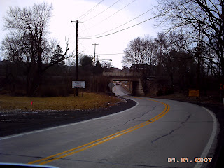
The Arch in Auburn Pennsylvania

The entrance to Auburn, PA. Commonly referred to as The Arch.
Here are some photos of the Arch in Auburn,PA. The Arch is also known as the entrance to Auburn. The Reading and Northern Railroad runs on the tracks that go over the Arch.

Years ago, people would hang out and socialize on the steps to the arch. It was a favorite place among teenagers of the time. This was before the internet and today's world of Facebook.

The arch also has a small dirt road right before the steps the leads back to the Auburn Canal. This was a very popular spot for fishing and also bush parties.

On the area to the right of the Arch is the Schuylkill River which has a small path/trail that leads to the Schuylkill River and is still quite popular with local fishermen.

The Arch in Auburn Pennsylvania
The actual street that runs under the Arch is known as Route 895 or Market Street in Auburn, PA.


Thursday, February 23, 2012

The Landingville Marsh Area Landingville, PA

The Landingville Marsh Area - Landingville, PA

A view of the Marsh Area from the Bartram Trail parking lot in Landingville, PA


Just past the marsh area in Landingville. This is near the entrance to the falls of the Auburn Dam. The Bartram Trail currently ends at the concrete barrier seen in this picture.
The Landingville Marsh Area is a great place for outdoor recreation. Some activities include fishing, walking, and bird watching. The marsh isn't fished much, but you can catch sunfish, bass, and pickerel there. The Bartram Trail runs along the one side of the marsh and allows you to connect to a trail that goes around the marsh and comes back out to the road. When you get near the road you will be alongside the Schuylkill River.


Signs posted along the marsh state the marsh area is home to 211 species of birds with 77 confirmed to be nesting in the area. The marsh is also very close to the Auburn / Landingville Dam which is heavily used for boating and fishing. The Dam is home to a large number of fish which include catfish, large mouth bass. small mouth bass, carp, perch, suckers, musky, pickerel, walleye, and pike. In the past few years some reports show trout in the dam. This is probably due to trout being stocked north of the dam in the Schuylkill River near Pottsville.

I will be taking more photos of the Marsh in the future and will upload them here.

Saturday, February 18, 2012

Lehigh and New England Trail Tamaqua, PA

A few weeks ago, I took and dogs and decided to check out the Lehigh and New England Trail in Tamaqua, PA. This trail is about 3 miles long or 2.7 miles as listed on www.traillink.com.

The trail is slightly south of Tamaqua on Dairy Road. Dairy Road is directly across Rt. 443 at the intersection of Rt. 443 and Rt. 309. Here is a map to show it better.


View Larger Map

When you get on Dairy Road, right as you pass the TLC Convenience Store on the right, the trail will be about 500 feet on the left. Right before the Lehigh and New England Trail is a paved area on the left where you can park. Its flat and paved, but not very large. You may want to go past the area and turn around so you are parking correctly and facing the proper way.

The trail is marked with a red pole or stake at the beginning which is viewable from the road or where you park. From Dairy Road, the trail starts with a slight hill going upwards. Once you go up the little hill, the trail is flat. The trail is about as wide as a vehicle. Although, the trail pretty much runs along Rt. 309, it is hidden by a dense amount of trees and makes for a great hiking or biking adventure.

Here are some pictures to give you a better look of the Lehigh and New England Trail in Tamaqua, PA.

The Lehigh and New England Trail looking towards the intersection of Rt. 443 and Rt. 309 along Dairy Road.

The Lehigh and New England Trail where it starts from Dairy Road. A slight hill until the top which then is all flat.

The Lehigh and New England Trail marker which sits to the right when you reach the top of the small entrance hill off Dairy Road.

A picture of the trail about 1/10 mile in. It runs north alongside Rt. 309.